The General Drone-Related Thread

St Walburge’s was designed by the architect Joseph Hansom and completed in 1854.

At a towering 309 ft, it is the tallest of any parish church in England. This spectacular spire is also the third tallest in the UK, giving you breathtaking views over the city. is a major, unique attraction for visitors who can climb the 173 spiral steps to obtain a magnificent 360 degree view over Preston city and westwards to Blackpool and the Irish Sea coast.

St Walburge's is recorded in the National Heritage List for England as a designated Grade I listed building.

The rose window is a beautifully-coloured circular window, 22 feet in diameter. The colour of the spire contrasts to that of the main body of the church because it’s made of a different stone- a limestone full of fossils. The Medieval leper hospital of St Mary Magdalene once stood here.

Music: Enya - So I Could Find My Way.

 
Nice video production there @Paul Iddon (y)

Shame m8, but it's not for everyone I suppose.

Paul.

ahh.. but will the weather be good enough for you to go walkies with it ?? grins

I’ve scratched the itch now so that’s fine. Weather didn’t help matters but I knew I’d struggle to find places to fly living in an FRZ and being a hermit.

What I should really be doing is making full use of my X100V instead of buying more kit :ROFLMAO::rolleyes:
 
Not long got back from a short trip around some of France and Belgium and just finished off the first video.

Started off with a couple of days in Le Touquet, a seaside town a little over an hour south of Calais with lovely sandy beaches and a favourite summer holiday destination for Parisians. Flying is quite restricted due to the proximity of an airport and a nature reserve, but there are a couple of interesting spots with a good size seal population that could have been interesting. Unfortunately is p***ed it down the whole time!

Next was a day in Disneyland, so no drone time, followed by a day in Paris where I think you are likely to be shot for even saying the word drone, so no action there either.

Then on to Belgium for a couple of days, staying in Bruges and visiting Pairi Daiza which is quite honestly the most amazing zoo that I have ever been too, well worth a visit. But I found the drone laws in Belgium too confusing and contradictory so didn't bother.

So then we started the drive back to Calais, taking a scenic detour through the countryside and then going via Dunkirk. I thought I was going to get home with the drone having never come out of the bag, but then I spotted this on the side of the road and couldn't resit it. It's a bit niche, I don't know if anyone here is a particularly big windmill fan (I am not) but it's all good practice.

View: https://youtu.be/HOE08_WeHRA
 
Last edited:
I’ve been out with my drone this morning, just to visit and photograph a couple of churches. I always ask for permission if there’s anyone on site. I asked a lady who turned out to be the church warden if I could take some pictures. She said that the roof needed repairing hence the scaffolding. The scaffolder told her that he couldn’t use his drone to survey the gutters and roof because it’s a listed building?
I just said “Oh don’t worry, I’ll just take a couple at ground level”.

Has anyone heard of such a thing, or is the scaffolder having her on?

EDIT:
Well I’ve been doing some research and it would appear that you can take photographs of almost any building from a public place, you do not need permission (Common sense should prevail here!)
 
Last edited:
Arnside Tower, Historical Ruin

Situated about a mile and a half outside of Arnside, and to the South East of Arnside Knott, Arnside tower is a spectacular and almost unique example of a Cumbrian pele tower.

The oldest building in the parish, the tower was built in the late 14 or early 15th century. These fortified homes were not built as castles or fortified as strongly but were built as towering homes that could help protect the area from Scottish raiders.

Arnside Tower stands astride a natural limestone knoll, with the sea protecting it on one side and marshes on the other. The main entrance was through a pointed arch on the north-east side and this gave access to the central staircase. A smaller entrance was constructed later on the south-east side and there was a second staircase in the south corner.In 1815, Arnside Tower was sold to Daniel Wilson of Dallam Tower and the tower has been owned by the family that reside there ever since.

In 1884, a great storm hit the coast, with devastating effect. The south-west side collapsed along with the central partition wall. The tower has remained in this ruined state to this day.

Music by Enya: The Loxian Gate.


Paul.
 
  • Like
Reactions: RIR
I’ve been out with my drone this morning, just to visit and photograph a couple of churches. I always ask for permission if there’s anyone on site. I asked a lady who turned out to be the church warden if I could take some pictures. She said that the roof needed repairing hence the scaffolding. The scaffolder told her that he couldn’t use his drone to survey the gutters and roof because it’s a listed building?
I just said “Oh don’t worry, I’ll just take a couple at ground level”.

Has anyone heard of such a thing, or is the scaffolder having her on?

EDIT:
Well I’ve been doing some research and it would appear that you can take photographs of almost any building from a public place, you do not need permission (Common sense should prevail here!)
More money to be made by erecting a scaffold, simple as that.
 
Okay what does everyone do with panoramic shots? I’ve changed setting to raw+jpeg.
What ever I do I can’t get the raw to look the same as the jpeg( will post samples when on computer later)
The perspective is always totally different as well as the curvature off the land( again I’m not sure which is actually more accurate)

Editing in LR I’ve tried the standard merge and also after editing each image, but there is no lens profile for the m3p.
I’ve also tried both the cylindrical and spherical and neither end in the same result.
I use the manual transform adjustments rather than relying on lens specific defaults. Just remember if your are trying to lose the fisheye effect it will result in a lot of white area to crop out, so you need to consider that when framing the shots.
 
My last video from my France trip. Would like to go back as there is a whole battery structure a little further up the coast which would make for a more interesting video than focusing on just one small blockhouse. But I was already pushing my luck with how much time I had to get back to Calais to catch my ferry. Something for next year perhaps.

View: https://youtu.be/9x3WcgOqXGM
 
Oh no, it's not in the drink is it?
It sure is. :(

I stopped using the DJI maps a while ago as they are generally not very accurate and dont show up to date information. Instead I have been using drone assist/altitude angel which seems to be recommended by just about everyone.

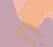
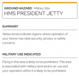
Turns out that in between where I was positioned and where the drone was flying there is the HMS President jetty, something I had not heard of before now. Although I checked drone assist this did not show up as I had the ground hazards filter turned off. In London there are hazards everywhere and it clutter the map, besides I had good view of where I was flying.

But, when you do look into it on drone assist, it seems to be something more than just a ground hazard, I wonder if it is miss-categorised?

1692860845952.png 1692860859771.png

The DJI map however shows it as a no fly zone. So when I tried to bring it back I hit the geofence and couldn't get it to move. Panic set in as the battery ticked down and the rest is history.
 
You really need to check the Altitude Angel site and the DJI fly safe site, even though the DJI site is really poor.

I had a problem where I had checked and logged the flight on Altitude Angle but when I got to site it turned out it was next to site a DJI deemed a military site, even though it had been sold off. I then had all the hassle of submitting an unlock request while on site, before I could take off.
Yes that is what I will do from now on.
 
I’ve been out with my drone this morning, just to visit and photograph a couple of churches. I always ask for permission if there’s anyone on site. I asked a lady who turned out to be the church warden if I could take some pictures. She said that the roof needed repairing hence the scaffolding. The scaffolder told her that he couldn’t use his drone to survey the gutters and roof because it’s a listed building?
I just said “Oh don’t worry, I’ll just take a couple at ground level”.

Has anyone heard of such a thing, or is the scaffolder having her on?

EDIT:
Well I’ve been doing some research and it would appear that you can take photographs of almost any building from a public place, you do not need permission (Common sense should prevail here!)
It would depend on the size of the drone, if it was over 250g and under the A3 category then it would need to be 150m from buildings although admittedly it's not the excuse the scaffolder gave.
Okay what does everyone do with panoramic shots? I’ve changed setting to raw+jpeg.
What ever I do I can’t get the raw to look the same as the jpeg( will post samples when on computer later)
The perspective is always totally different as well as the curvature off the land( again I’m not sure which is actually more accurate)

Editing in LR I’ve tried the standard merge and also after editing each image, but there is no lens profile for the m3p.
I’ve also tried both the cylindrical and spherical and neither end in the same result.
I take 180 panorama shots then merge them in Lightroom although I seem to recall on the newer models of drones, they stitch the panoramas differently for the jpegs than normal stitches do
For those who use drones, watch this and take the survey a.s.a.p.
I think they're long overdue looking into the current drone categories as they make absolutely no sense, it's absurd that a drone like the Mini 3 Pro is completely exempt from most regulations but very similar but slightly heavier drones are subject to the very strict A3 rules requiring them to be kept 150m away. While pilots can gain the A2 classification, it's still more restrictive than an unqualified pilot in the A1 class. The European classification system made more sense allowing classified drones into the A1 category if they met certain requirements but then the CAA didn't follow those rules.
 
One of the reasons I got rid of my new drone - I like to enjoy my hobbies not be constantly worried about ‘the rules‘, whether or not I was breaking them and Karen’s sticking their oar in.

If they’re getting stricter I’m even gladder I don’t have one anymore :exit:
 
Buried... Preston's Real Life Witch... A must see to the very end....

Meg Shelton (died 1705) known as the "Fylde Hag" was an English woman accused of witchcraft. Her grave can be seen at St. Anne's Church in Woodplumpton, now part of the City of Preston district of Lancashire. Meg Shelton's real name is recorded by St Anne's Church as Margery Hilton.

The Woodplumpton 'witch' is reputedly buried upside down with a boulder on her grave...

Accused of using witchcraft to destroy crops, steal milk and transform herself into animals, Meg Shelton was subject of many fantastical tales and stories. Most traditions have her body being found crushed against her cottage wall by a barrel. According to some versions of the story, the unusual death was seen by villagers as a sign that the Devil had come to claim her.

Meg Shelton was buried in St Anne's churchyard, but her body refused to stay underground. The following morning, her corpse was found lying beside her grave. She was reburied, and once more her corpse reappeared. Finally, the priest performed an exorcism and Shelton was buried for the third time, but this time she was interred in a narrow vertical hole, like an oversized post hole, and she was inserted upside down, so that if she tried to dig her way to the surface she'd be going the wrong way. Finally, a boulder was placed over the top of her unusually-shaped grave.

You'll see her tomb three or four times in my flight... Can you spot it??? Dare you look?


Paul.
 
Last edited:
The Mellor Millennium Viewpoint, Blackburn.

223 metres above sea level, the moor-top at Mellor, a little north of Blackburn, Lancashire, is the site of the Millennium viewpoint, where on clear days fantastic views can be had of the Yorkshire Dales and West Pennine Moors, the Lake District, Furness, the whole of the Fylde coast, the Isle of Man and Snowdonia, as well as more local features such as the Bowland Fells, Ribble Valley, Pendle Hill, Blackpool Tower.

The Millennium Disc was erected in 2002 as part of the village’s celebrations.It guides walkers on the moor as to the places they can see from the viewpoint. Buried beneath the stone circle is a time capsule, put together by pupils at St Mary’s School.

Uniquely this modest hill of 223m, has a defunct Royal Observation Nuclear Blast and Fallout Monitoring Station from the cold war era . The monitoring post was opened in July 1959, and was decommissioned in October 1968. Many local people still believe that this was a nuclear shelter for the use of the population during times of war.


Paul
 
Back
Top